


Forager's Buddy - GPS foraging
Descrizione di Forager's Buddy - GPS foraging
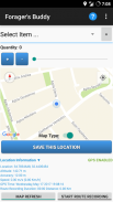
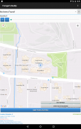
Forager's Buddy è un'applicazione gratuita per smartphone e tablet Android, progettata per aiutare gli utenti a segnare sulla mappa tutti i luoghi notevoli, dove possono trovare vari tipi di risorse di cibo selvatico (Utilizzando il modulo GPS del dispositivo).
Puoi utilizzare questa app di foraggiamento in varie attività all'aperto come raccolta di erbe selvatiche/funghi, caccia, pesca, campeggio, escursionismo, ecc.
Importante: Android 10+ ha nuove impostazioni per le autorizzazioni di posizione. Affinché la registrazione del percorso di Forager's Buddy funzioni correttamente, è necessario selezionare l'opzione "Consenti sempre" (da Info app -> Autorizzazioni app -> Posizione).
Guida rapida di riferimento di Forager's Buddy [PDF] - https://bit.ly/3usgDt6
Tutorial rapido di Forager's Buddy 1 [Video] - https://youtu.be/jWCD6dVO3II
Tutorial rapido di Forager's Buddy 2 [Video] - https://youtu.be/s9DHd6lT160
Tutorial rapido di Forager's Buddy 3 [Video] - https://youtu.be/2TmSqWIxSC0
Tutorial rapido di Forager's Buddy 4 [Video] - https://youtu.be/f-jYRJls89Q
Tutorial rapido di Forager's Buddy 5 [Video] - https://youtu.be/Ssx1a3Y-C1I
Sentiti libero di parlarci dei cambiamenti che vorresti vedere in Forager's Buddy.
Caratteristiche (edizione gratuita):
1. Selezione tra unità del sistema imperiale e metrico
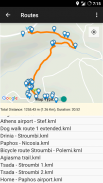
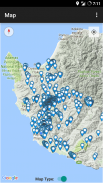
2. Registrazione e visualizzazione del percorso (Esportazione del percorso in formato file .kml)**. C'è la possibilità di visualizzare i punti vicini e convertire i file di percorso .kml in formato .gpx
3. Esportazione e importazione di dati come CSV.
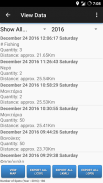
4. Filtraggio dei dati.
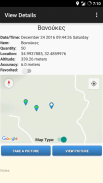
5. Allega una foto a una posizione
6. Visualizzazione della distanza approssimativa di ciascun elemento dalla posizione corrente dell'utente.
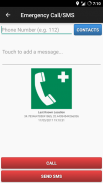
7. Chiamata di emergenza e SMS (invia un SMS con l'ultima posizione nota dell'utente e lo stato della batteria del dispositivo).
8. Preferiti.
9. Condivisione della posizione dell'articolo (ad es. tramite e-mail o SMS).
10. Condivisione della posizione corrente (ad es. tramite e-mail o SMS).
11. Condivisione di file CSV (ad es. tramite e-mail o Bluetooth).
12. Condivisione di file di percorso KML (ad es. tramite e-mail o Bluetooth).
13. Posizioni personalizzate. Gli utenti possono salvare i punti personalizzati dalla schermata principale, facendo clic a lungo sulla posizione desiderata sulla mappa.
14. Backup automatico (esportazione in .csv) ogni volta che l'utente apporta modifiche.
15. Tema oscuro
16. Puoi facilmente trovare cosa cercare nel mese corrente (in base alle tue scoperte precedenti)
Caratteristiche (edizione Pro):
1. Tutte le funzionalità dell'edizione gratuita / Senza pubblicità
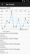
2. La mia attività. Rappresentazione grafica del numero di articoli raccolti ogni mese.
3. Radar. Visualizza una mappa e un elenco degli elementi raccolti dall'utente. La mappa si aggiorna ogni 3 secondi. La portata del radar è regolabile: 0 – 1000 metri.
4. Posizioni personalizzate. Gli utenti possono salvare i punti personalizzati dalla schermata "Visualizza mappa", facendo clic a lungo sulla posizione desiderata sulla mappa.
5. Condizioni meteorologiche attuali per la posizione degli elementi correnti e salvati.
6. Esporta i dati in formato file .kml (gli utenti che utilizzano strumenti come Google My Maps, possono utilizzare questa funzione per creare mappe personalizzate per i propri siti Web o blog).**
7. Esporta i dati in formato file .gpx.
8. Cerca nelle note.
9. Crea promemoria nel calendario.
10. Mostra luoghi vicini (nella schermata Mostra dettagli oggetto).
I file esportati da Forager's Buddy (.csv, .gpx e .kml), possono essere facilmente importati nel software GIS (Geographic Information System) (come QGIS), per ulteriori analisi dei dati geografici.
Permessi:
1. Contatti/Telefono - Per la funzione "Chiamata di emergenza/SMS". Gli utenti possono selezionare un contatto da chiamare o inviare un SMS in caso di emergenza (invia anche l'ultima posizione nota dell'utente e lo stato della batteria del dispositivo)
2. Posizione - Per ovvi motivi :)
3. Archiviazione - Per archiviare file esportati come: spot (.kml, .csv), percorsi (.kml) e foto
Sei un blogger o un giornalista? Richiedi un codice promozionale di Google Play per testare l'edizione Buddy PRO di Forager! https://goo.gl/ufpt7M
** KML è un formato di file utilizzato per visualizzare i dati geografici in un browser Earth come Google Earth, Google Maps e Google Maps per dispositivi mobili.
Forager's Buddy - GPS foraging - Versione 3.8.2
(02-08-2024)Forager's Buddy - GPS foraging - Informazioni APK
Versione APK: 3.8.2Pacchetto: com.gh_its.foragersbuddyUltima versione di Forager's Buddy - GPS foraging
Altre versioni


App nella stessa categoria

Potrebbe piacerti anche...


